
FAQ’S
Subdivision Process FAQ
-
Applications for subdivision can be sent by regular letter mail to:
Municipal Planning Services (2009) Ltd.
#206 17511 – 107 Avenue NW
Edmonton, Alberta T5S 1E5Further information can be obtained by contacting Municipal Planning Services (2009) Ltd.
PHONE : 780.486.1991
FAX : 780.483.7326
EMAIL : admin@munplan.ab.ca
ONLINE : www.munplan.ab.ca -
Subdivision refers to the process of adjusting the boundaries of a parcel of land to:
• Change the dimensions of an existing parcel;
• Create new/additional parcels of land; or
• Reduce the number of parcels of land.New subdivisions must be approved by the municipality’s Subdivision Authority before the new property boundaries can be registered with the Alberta Land Titles Office.
MPS is the designated Subdivision Authority (or Subdivision Authority Officer) for our municipal clients.
The subdivision process can be quite complex. Although a landowner (or their representative) can apply for a subdivision, engaging the services of a professional Alberta Land Surveyor, Planner, Lawyer, or Engineer who is familiar with planning regulations in Alberta is recommended. Properly prepared applications usually proceed at a faster rate, and registration at the Land Titles Office can be achieved sooner.
A subdivision cannot be registered without the landowner engaging a professional Alberta Land Surveyor to determine the boundaries for plan registration at the Land Titles Office. We recommend contacting surveyors in your area for quotes before you submit your application.
Under the Municipal Government Act, R.S.A. 2000, c. M-26, (MGA) as amended, before the Land Titles Office can register a Plan or another instrument creating a subdivision, the subdivision must be “approved” by the municipality’s Subdivision Authority. The process (described on the next page) for processing and issuing decisions for subdivision applications is established in the MGA.
Under the Municipal Government Act, R.S.A. 2000, c. M-26, as amended, municipal Councils appoint Subdivision Authorities. In several municipalities, the Subdivision Authority or the Authority’s Officer is Jane Dauphinee, RPP, MCIP, who works through a private company, Municipal Planning Services (2009) Ltd. Please contact our office to confirm who the Subdivision Authority is prior to submitting your plan.
A process chart summarizing the subdivision process is included on the next page of this guide.
-
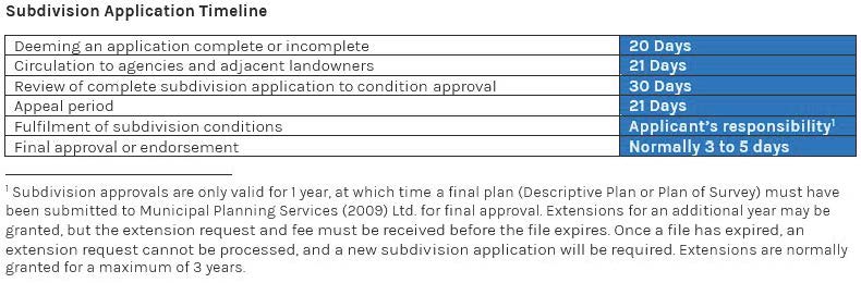
Generally, a subdivision takes approximately 3 to 6 months to complete (from time of application to approval). Below is a timeline of key steps in the application/approval process, as mandated by provincial legislation.
-
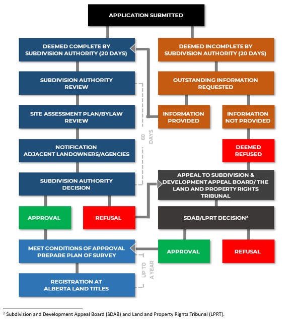
Below is a flow chart illustrating the subdivision process.
For a more comprehensive overview of the process, with explanations outlining each step, go to our Subdivision Process page.
-
Generally, the costs for a subdivision are as follows:
Fee due at application (see fee schedule for more information).
Fulfillment of any conditions specified in the decision (dependent on conditions - may include building roads, accesses, sewer, and water lines, etc., off-site levies, etc.).
Preparation of Descriptive Plan or Plan of Survey to effect plan (contact an Alberta Land Surveyor to discuss costs).
Note: Flagstaff County requires a Plan of Survey for all subdivisions.Fee due at endorsement (final approval).
Registration of the Plan and/or other instruments at the Alberta Land Titles Office.
G.S.T is payable on all fees.
-
The following is a list of application requirements needed to provide a completed subdivision application:
Application Fee (Please refer to applicable MPS fee schedule)
FORM 1 | Application for Subdivision (must be completed in full and signed)
FORM 2A or 2B | Alberta Energy Regulator (AER) Abandoned Wells Statement (whichever is applicable)
FORM 3A | Authorization for Electronic Communication
FORM 4 | Tell Us About Your Sewage Disposal System
**To be completed for each private sewage disposal system on the subject property**FORM 5 | Landowner Letter of Authorization
**Must accompany all applications where the applicant is not the landowner OR where there is more than one registered landowner. Please note that signatures are required for ALL registered landowners**Certificate of Title (obtained within 3 months of the submission of the application)
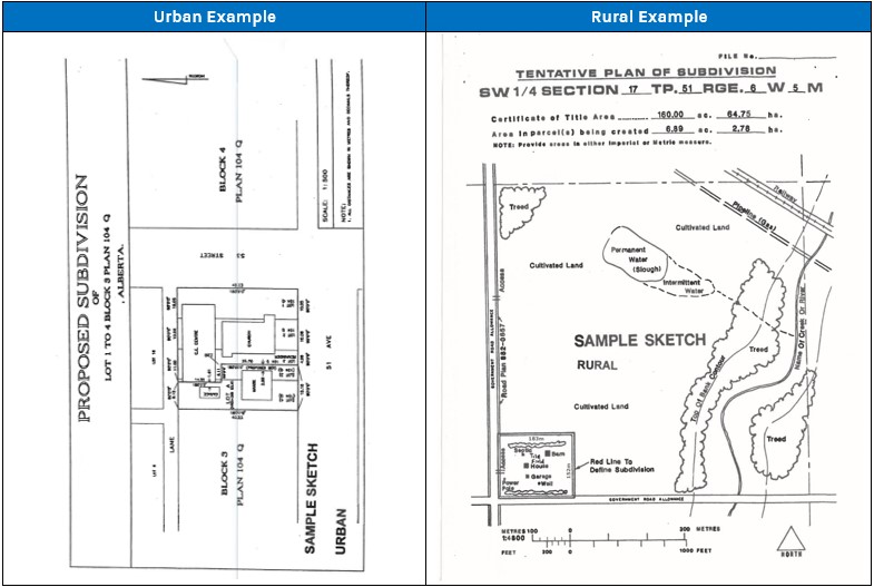
**Please note that if one is not provided, we may acquire one on your behalf for a fee**Tentative Plan of Subdivision (with area and dimensions of the proposed lot(s) and remainder parcel)
An orthophoto of the subject site (including proposed and remainder parcels)
Any other items or information identified during pre-submission consultation.
-
-
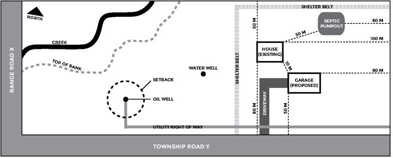
Below are the standard site plan requirements for all subdivision applications. Additional requirements specific to your application may be required once the application has been reviewed by our office.
Checklist for applicants
☐ Dimensions of property boundaries (meters).
☐ Indicate setback distances from all property boundaries for new and existing developments and specify the units of measurement (metres). Minimum setback requirements are identified in the municipality’s Land Use Bylaw.
☐ Indicate the direction of north on the site plan.
☐ Indicate the distances between existing and proposed structures.
☐ Identify and label all roads that abut the subject property.
☐ Identify the location of all easements, caveats, rights-of-way, etc.
☐ Indicate the location of any accesses/approaches to the subject property (existing or proposed).
☐ Indicate the location of any active or abandoned oil/gas wells, pipelines, and/or facilities.
☐ Indicate the location of any water wells and sewage disposal systems and the distance between these facilities and the proposed buildings and property boundaries.
☐ Indicate the location and distance to existing natural features (e.g., water courses, wooded areas, water bodies including wetlands, ravines, etc.) and man-made features (berms, drainage ditches, etc.).
☐ Identify the location of all existing, temporary, to be removed/demolished, moved-in, and proposed structures (e.g., dwellings, sheds, signs, etc.).
☐ Identify the direction of site grading and drainage.
Site Plan Example:
This plan is intended for illustration purposes; it will not be accepted as a site plan for a subdivision application. -
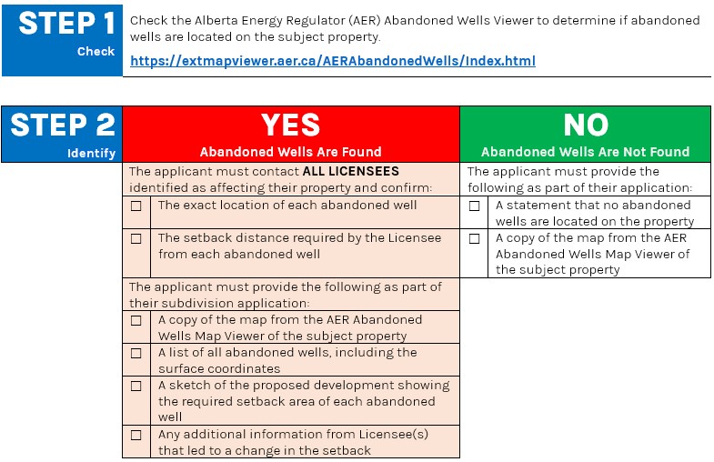
Provincial subdivision and development regulations require that applicants for new subdivisions provide information about abandoned oil and gas wells on the subject property.
Before an application for subdivision or development can be considered, applicants must provide this information. By having the landowner (or agent acting on behalf of the landowner) conduct this search it can prevent damage to wells and excavation equipment, as well as injury to equipment operators and landowners/occupants.
The following chart outlines the process for determining what information is required depending on whether abandoned wells are located on the property.
**See the corresponding Abandoned Wells Process FAQ’s for further information
Abandoned Well Process FAQ
-
An agent can sign the required statement on behalf of the registered landowner. The wording of the Alberta Energy Regulator’s (AER) Directive 79 requires “confirmation from the applicant.”
The applicant, whether the landowner or an agent acting on behalf of the owner, can sign the statement and provide written confirmation.
-
The landowner, or agent acting on behalf of the landowner, must contact all licensees on the affected property. The licensee(s) are then required to physically locate the abandoned well(s).
To demonstrate that this has occurred, MPS will require the following:
GPS coordinates of the well site(s); and
A sketch of the site showing the exact location of the well(s) on the property and the required setback distance from the well site(s).
This information must be provided by the licensee or an Alberta Land Surveyor.
-
The AER’s Directive 79 states: “If an applicant is unable to contact the licensee of record using the information provided by the [AER Abandoned Wells Map] viewer or the [AER] Information Management Branch, the AER may be able to supply additional contact information.”
Well(s) must be located and tested as per Directive 079 requirements. The developer may choose to hire professionals to locate and test the well(s) and assume the associated costs.
As per Directive 079, if a methane anomaly is detected, the test results must be immediately submitted to the AER at Directive079@aer.ca. The associated cost to locate and test for leaks in abandoned wells will generally be the responsibility of the developer where the license is no longer viable.
-
Yes. A subdivision application submitted to MPS will not be deemed complete until all relevant information regarding abandoned oil and gas wells has been provided in full by the applicant.
